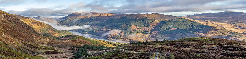
File:Loch Lubnaig from the path to Ben Ledi, Scotland.jpg
From Eco Friendly Travels

Size of this preview: 800 × 192 pixels. Other resolutions: 320 × 77 pixels | 640 × 154 pixels | 1,024 × 246 pixels | 1,280 × 307 pixels | 20,997 × 5,039 pixels.
Original file (20,997 × 5,039 pixels, file size: 59.19 MB, MIME type: image/jpeg)
| Warning | The original file is very high-resolution. It might not load properly or could cause your browser to freeze when opened at full size. |
|---|
Summary
| Description |
Magyar: A Lubnaig-tó látképe a Ben Ledire vezető útról (Skócia)
Македонски: Езерото Лох Луни од патеката кон планината Бен Леди, Шкотска
Nederlands: Loch Lubnaig, een van de lochs in het Schotse Nationaal park Loch Lomond en de Trossachs
Português: Panorâmica do lago Lubnaig visto do caminho para a montanha Ben Ledi, Escócia.
Українська: Озеро Лох Луни, Шотландія |
| Date | |
| Source | Own work |
| Author | Michal Klajban |
| Other versions |
_P-SCO_Panorama.jpg)
| Object location | | View this and other nearby images on: OpenStreetMap |
|---|
| Camera location | | View this and other nearby images on: OpenStreetMap |
|---|
The production, editing or release of this file was supported by the Community-Budget of Wikimedia Deutschland. To see other files made with the support of Wikimedia Deutschland, please see the category Supported by Wikimedia Deutschland. |
Assessment
|
This image was selected as picture of the day on Wikimedia Commons for 14 November 2019. It was captioned as follows: Other languages:
Magyar: A Lubnaig-tó látképe a Ben Ledire vezető útról (Skócia) Nederlands: Loch Lubnaig, een van de lochs in het Schotse Nationaal park Loch Lomond en de Trossachs Português: Panorâmica do lago Lubnaig visto do caminho para a montanha Ben Ledi, Escócia. Македонски: Езерото Лох Луни од патеката кон планината Бен Леди, Шкотска Українська: Озеро Лох Луни, Шотландія |
Licensing
I, the copyright holder of this work, hereby publish it under the following license:
This file is licensed under the Creative Commons Attribution-Share Alike 4.0 International license.
- You are free:
- to share – to copy, distribute and transmit the work
- to remix – to adapt the work
- Under the following conditions:
- attribution – You must give appropriate credit, provide a link to the license, and indicate if changes were made. You may do so in any reasonable manner, but not in any way that suggests the licensor endorses you or your use.
- share alike – If you remix, transform, or build upon the material, you must distribute your contributions under the same or compatible license as the original.
File history
Click on a date/time to view the file as it appeared at that time.
| Date/Time | Thumbnail | Dimensions | User | Comment | |
|---|---|---|---|---|---|
| current | 20:34, 10 February 2019 | 20,997 × 5,039 (59.19 MB) | Podzemnik | working on the right bottom |
File usage
The following page uses this file: