File:ONCF DH 370 with a Casablanca - Oujda train at the Barrage Idriss 1er.jpg
From Eco Friendly Travels

Size of this preview: 800 × 494 pixels. Other resolutions: 320 × 197 pixels | 640 × 395 pixels | 1,024 × 632 pixels | 1,280 × 790 pixels | 4,665 × 2,879 pixels.
Original file (4,665 × 2,879 pixels, file size: 10.39 MB, MIME type: image/jpeg)
Summary
| Description |
العربية: قاطرة الديزل DH 370 سلسلة (EMD GT26CW-2) التابعة للمكتب الوطني للسكك الحديدية - المغرب (ONCF) تسحب القطار الذي يربط يوميًا مدينة الدار البيضاء بوجدة، الصورة بين منطقتي الطوابع ومطماطة. حل الديزل محل القاطرة الكهربائية في فاس لخدمة هذا الجزء غير المكهرب من الخط. المسطح المائي في الخلفية هو بحيرة سد إدريس الأول.
Deutsch: Eine ONCF DH 370 (EMD GT26CW-2) mit dem Tagzug von Casablanca nach Oujda, zwischen Et-Touabaâ und Matmata. Eine E-Lok brachte den Zug nach Fes, wo sie durch eine Diesellok ersetzt wurde. Der See im Hintergrund ist der Barrage ("Staumauer/Stausee") Idriss 1er.
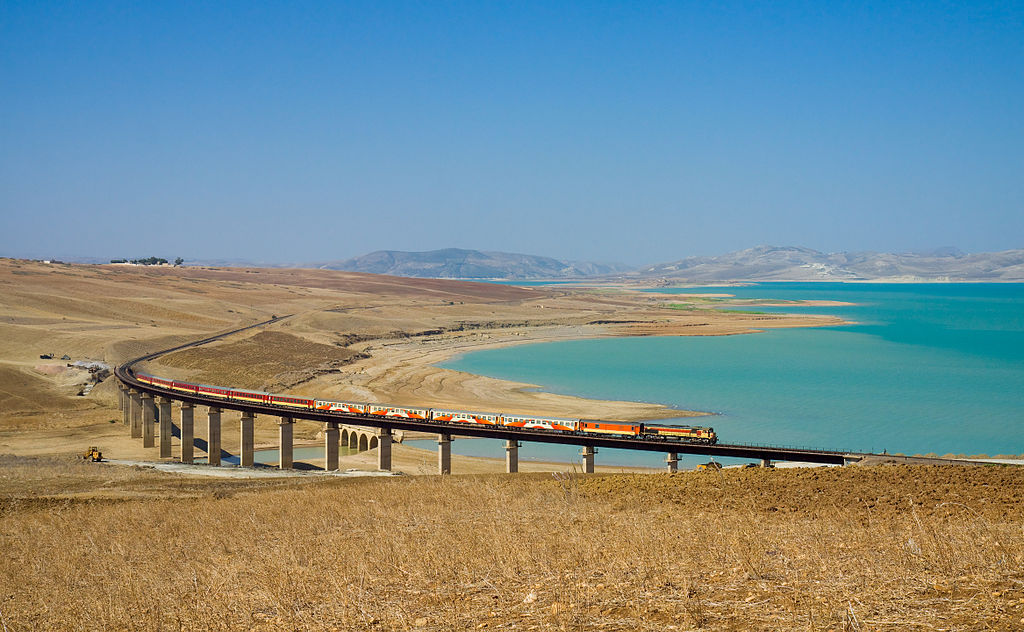
English: An ONCF DH 370 (EMD GT26CW-2) with the daytime train from Casablanca to Oujda, between Et-Touabaâ and Matmata. An electric locomotive brought the train to Fes, where it was swapped for the DH 370. The lake in the background is the Barrage ("dam") Idriss 1er.
Français : Une locomotive diesel de l'ONCF (Société des chemins de fer marocains) de la série DH 370 (EMD GT26CW-2) tire le train qui relie chaque jour Casablanca à Oujda photographié ici entre Et-Touabaâ et Matmata. Le diesel a remplacé la locomotive électrique à Fez pour desservir cette portion de la ligne non électrifiée. Le plan d'eau en arrière-plan est le lac du barrage Idriss 1er. |
| Date | |
| Source | Own work: http://bahnbilder.ch/picture/9369 |
| Author | Kabelleger / David Gubler (http://www.bahnbilder.ch) |
| Camera location | | View this and other nearby images on: OpenStreetMap |
|---|
|
This image was selected as picture of the day on Vietnamese Wikipedia.
|
Licensing
I, the copyright holder of this work, hereby publish it under the following licenses:

|
Permission is granted to copy, distribute and/or modify this document under the terms of the GNU Free Documentation License, Version 1.2 or any later version published by the Free Software Foundation; with no Invariant Sections, no Front-Cover Texts, and no Back-Cover Texts. A copy of the license is included in the section entitled GNU Free Documentation License. |
This file is licensed under the Creative Commons Attribution-Share Alike 3.0 Unported, 2.5 Generic, 2.0 Generic and 1.0 Generic license.
- You are free:
- to share – to copy, distribute and transmit the work
- to remix – to adapt the work
- Under the following conditions:
- attribution – You must give appropriate credit, provide a link to the license, and indicate if changes were made. You may do so in any reasonable manner, but not in any way that suggests the licensor endorses you or your use.
- share alike – If you remix, transform, or build upon the material, you must distribute your contributions under the same or compatible license as the original.
You may select the license of your choice.
| Annotations | This image is annotated: View the annotations at Commons |
File history
Click on a date/time to view the file as it appeared at that time.
| Date/Time | Thumbnail | Dimensions | User | Comment | |
|---|---|---|---|---|---|
| current | 18:28, 26 October 2011 | | 4,665 × 2,879 (10.39 MB) | Kabelleger | Sky denoised, using PS' highest JPEG quality |
File usage
The following page uses this file: