Original file (4,419 × 2,936 pixels, file size: 8.85 MB, MIME type: image/jpeg)
This file is from Wikimedia Commons and may be used by other projects. The description on its file description page there is shown below.
Summary
DescriptionPlaza La Libertad I.jpg |
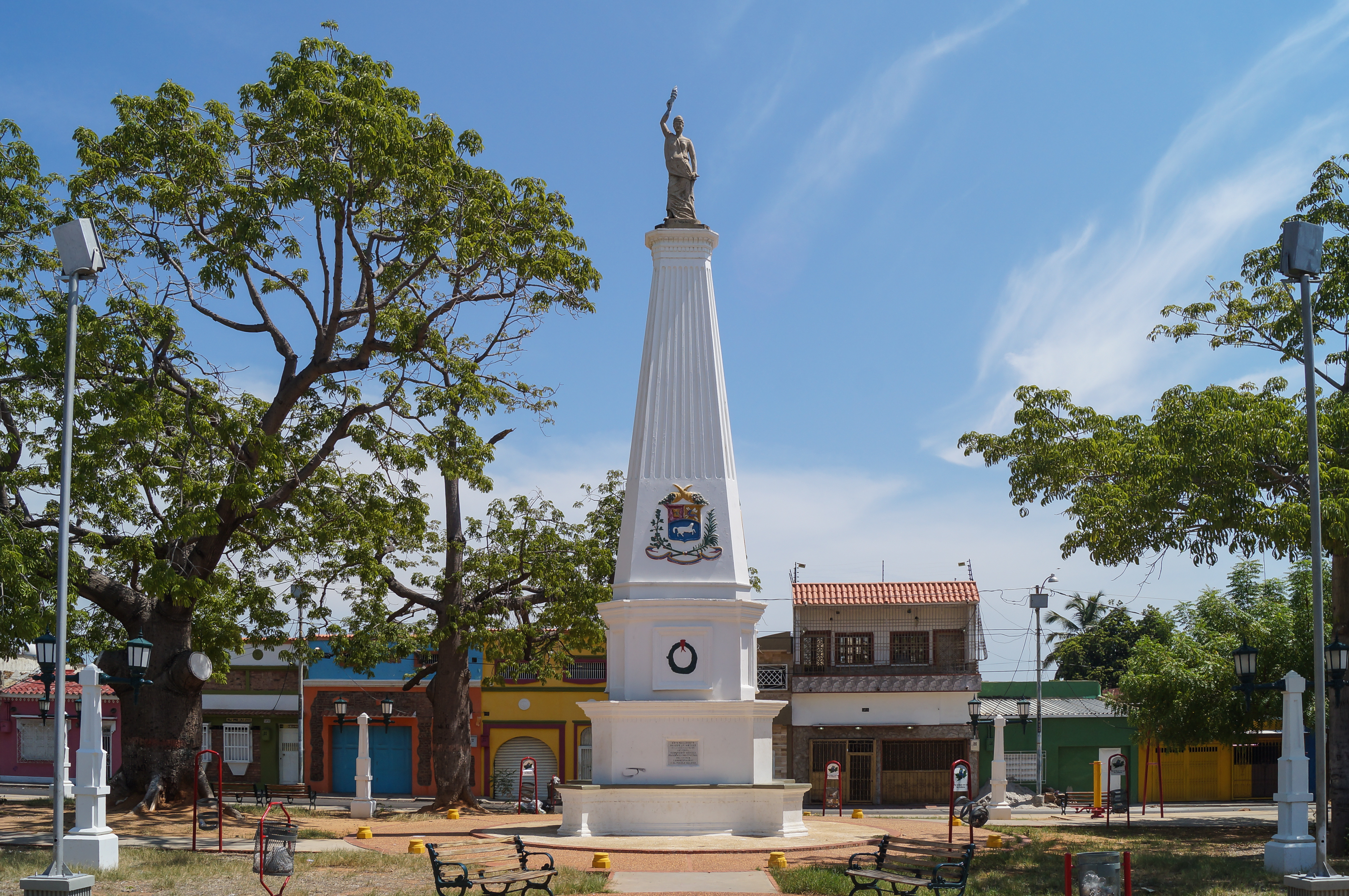
Español: La plaza es también conocida como plaza de la muñeca, está conformada por una planta rectangular con un esquema en forma de cruz para las caminerías, que se une en torno a un elemento central que semeja un pequeño obelisco y remata con una estatua femenina que simboliza la libertad. Cuenta con vegetación. La rodea un conjunto urbano conformado por 48 inmuebles aproximadamente, de tipología residencial tradicional. Este espacio funciona como puerta de entrada al barrio Santa Lucía hacia el este. Complementan la plaza bancos de madera y faroles que se ubican sobre pedestales de forma piramidal. Maracaibo.
|
||
Date | |||
Source | Own work | ||
Author | Rjcastillo |
Camera location | 10° 38′ 52.6″ N, 71° 36′ 19.63″ W | View this and other nearby images on: OpenStreetMap | 10.647945; -71.605453 |
---|
This image was uploaded as part of Wiki Loves Monuments 2013.
Afrikaans ∙ Alemannisch ∙ azərbaycanca ∙ Bahasa Indonesia ∙ Bahasa Melayu ∙ Bikol Central ∙ bosanski ∙ brezhoneg ∙ català ∙ čeština ∙ Cymraeg ∙ dansk ∙ davvisámegiella ∙ Deutsch ∙ eesti ∙ English ∙ español ∙ Esperanto ∙ euskara ∙ français ∙ Frysk ∙ Gaeilge ∙ galego ∙ hrvatski ∙ Ido ∙ italiano ∙ latviešu ∙ Lëtzebuergesch ∙ Malagasy ∙ magyar ∙ Malti ∙ Nederlands ∙ norsk ∙ norsk nynorsk ∙ norsk bokmål ∙ polski ∙ português ∙ português do Brasil ∙ română ∙ shqip ∙ sicilianu ∙ slovenčina ∙ slovenščina ∙ suomi ∙ svenska ∙ Tagalog ∙ Türkçe ∙ Yorùbá ∙ Zazaki ∙ Ελληνικά ∙ беларуская ∙ беларуская (тарашкевіца) ∙ български ∙ кыргызча ∙ македонски ∙ русский ∙ српски / srpski ∙ українська ∙ ქართული ∙ հայերեն ∙ नेपाली ∙ हिन्दी ∙ বাংলা ∙ മലയാളം ∙ ไทย ∙ 한국어 ∙ +/− |
Licensing
- You are free:
- to share – to copy, distribute and transmit the work
- to remix – to adapt the work
- Under the following conditions:
- attribution – You must give appropriate credit, provide a link to the license, and indicate if changes were made. You may do so in any reasonable manner, but not in any way that suggests the licensor endorses you or your use.
- share alike – If you remix, transform, or build upon the material, you must distribute your contributions under the same or compatible license as the original.
This image has been assessed using the Quality image guidelines and is considered a Quality image.
العربية ∙ جازايرية ∙ беларуская ∙ беларуская (тарашкевіца) ∙ български ∙ বাংলা ∙ català ∙ čeština ∙ Cymraeg ∙ Deutsch ∙ Schweizer Hochdeutsch ∙ Zazaki ∙ Ελληνικά ∙ English ∙ Esperanto ∙ español ∙ eesti ∙ euskara ∙ فارسی ∙ suomi ∙ français ∙ galego ∙ עברית ∙ हिन्दी ∙ hrvatski ∙ magyar ∙ հայերեն ∙ Bahasa Indonesia ∙ italiano ∙ 日本語 ∙ Jawa ∙ ქართული ∙ 한국어 ∙ kurdî ∙ Lëtzebuergesch ∙ lietuvių ∙ македонски ∙ മലയാളം ∙ मराठी ∙ Bahasa Melayu ∙ Nederlands ∙ Norfuk / Pitkern ∙ polski ∙ português ∙ português do Brasil ∙ rumantsch ∙ română ∙ русский ∙ sicilianu ∙ slovenčina ∙ slovenščina ∙ shqip ∙ српски / srpski ∙ svenska ∙ தமிழ் ∙ తెలుగు ∙ ไทย ∙ Tagalog ∙ Türkçe ∙ toki pona ∙ українська ∙ vèneto ∙ Tiếng Việt ∙ 中文 ∙ 中文(简体) ∙ 中文(繁體) ∙ +/− |
15 September 2013
10°38'52.60114"N, 71°36'19.63256"W
File history
Click on a date/time to view the file as it appeared at that time.
Date/Time | Thumbnail | Dimensions | User | Comment | |
---|---|---|---|---|---|
current | 17:33, 20 September 2013 | 4,419 × 2,936 (8.85 MB) | Rjcastillo | User created page with UploadWizard |
File usage
The following page uses this file:
Metadata
This file contains additional information, probably added from the digital camera or scanner used to create or digitize it.
If the file has been modified from its original state, some details may not fully reflect the modified file.
Camera manufacturer | SONY |
---|---|
Camera model | SLT-A37 |
Exposure time | 1/400 sec (0.0025) |
F Number | f/9 |
ISO speed rating | 100 |
Date and time of data generation | 10:36, 15 September 2013 |
Lens focal length | 18 mm |
Latitude | 10° 38′ 52.6″ N |
Longitude | 71° 36′ 19.63″ W |
Horizontal resolution | 240 dpi |
Vertical resolution | 240 dpi |
Software used | Adobe Photoshop Lightroom 4.4 (Windows) |
File change date and time | 10:36, 15 September 2013 |
Exposure Program | Aperture priority |
Exif version | 2.3 |
Date and time of digitizing | 10:36, 15 September 2013 |
APEX shutter speed | 8.643856 |
APEX aperture | 6.33985 |
APEX brightness | 10.2984375 |
APEX exposure bias | 0 |
Maximum land aperture | 3.6171875 APEX (f/3.5) |
Metering mode | Pattern |
Light source | Unknown |
Flash | Flash did not fire, compulsory flash suppression |
File source | Digital still camera |
Scene type | A directly photographed image |
Custom image processing | Normal process |
Exposure mode | Auto exposure |
White balance | Auto white balance |
Digital zoom ratio | 1 |
Focal length in 35 mm film | 27 mm |
Scene capture type | Standard |
Contrast | Normal |
Saturation | Normal |
Sharpness | Normal |
GPS time (atomic clock) | 10:36 |
Geodetic survey data used | WGS-84 |
GPS date | 15 September 2013 |
GPS tag version | 0.0.2.2 |
Lens used | DT 18-55mm F3.5-5.6 SAM |
Date metadata was last modified | 15:59, 15 September 2013 |
Unique ID of original document | 19D31E586C01F0D3CD226B519B96C5A4 |
IIM version | 4 |