File:Pont de Pierre de nuit - Bordeaux.jpg
From Eco Friendly Travels

Size of this preview: 800 × 600 pixels. Other resolutions: 320 × 240 pixels | 640 × 480 pixels | 1,024 × 768 pixels | 1,280 × 960 pixels | 4,000 × 3,000 pixels.
Original file (4,000 × 3,000 pixels, file size: 4.32 MB, MIME type: image/jpeg)
Summary
| Description |
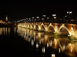
Français : Le pont de pierre de nuit, à Bordeaux (avec l'église sainte-marie la bastide en arrière plan) English: The "Stone bridge", by night, in Bordeaux (with the church sainte-marie la bastide in the background) |
| Date | |
| Source | Own work |
| Author | Fabien.lotte |
| Object location | | View this and other nearby images on: OpenStreetMap |
|---|
Licensing
I, the copyright holder of this work, hereby publish it under the following license:
This file is licensed under the Creative Commons Attribution-Share Alike 3.0 Unported license.
- You are free:
- to share – to copy, distribute and transmit the work
- to remix – to adapt the work
- Under the following conditions:
- attribution – You must give appropriate credit, provide a link to the license, and indicate if changes were made. You may do so in any reasonable manner, but not in any way that suggests the licensor endorses you or your use.
- share alike – If you remix, transform, or build upon the material, you must distribute your contributions under the same or compatible license as the original.

|
This image was uploaded as part of Wiki Loves Monuments 2011.
|
|
This building is inscrit au titre des monuments historiques de la France. It is indexed in the base Mérimée, a database of architectural heritage maintained by the French Ministry of Culture, under the reference PA33000067
|
File history
Click on a date/time to view the file as it appeared at that time.
| Date/Time | Thumbnail | Dimensions | User | Comment | |
|---|---|---|---|---|---|
| current | 12:36, 10 September 2011 | | 4,000 × 3,000 (4.32 MB) | Fabien.lotte |
File usage
The following page uses this file: