File:Tulum - God of the Winds Temple 03.JPG
From Eco Friendly Travels
Size of this preview: 800 × 451 pixels. Other resolutions: 320 × 180 pixels | 640 × 361 pixels | 1,024 × 577 pixels | 1,280 × 721 pixels | 4,750 × 2,676 pixels.
Original file (4,750 × 2,676 pixels, file size: 9.2 MB, MIME type: image/jpeg)
Summary
| Description |
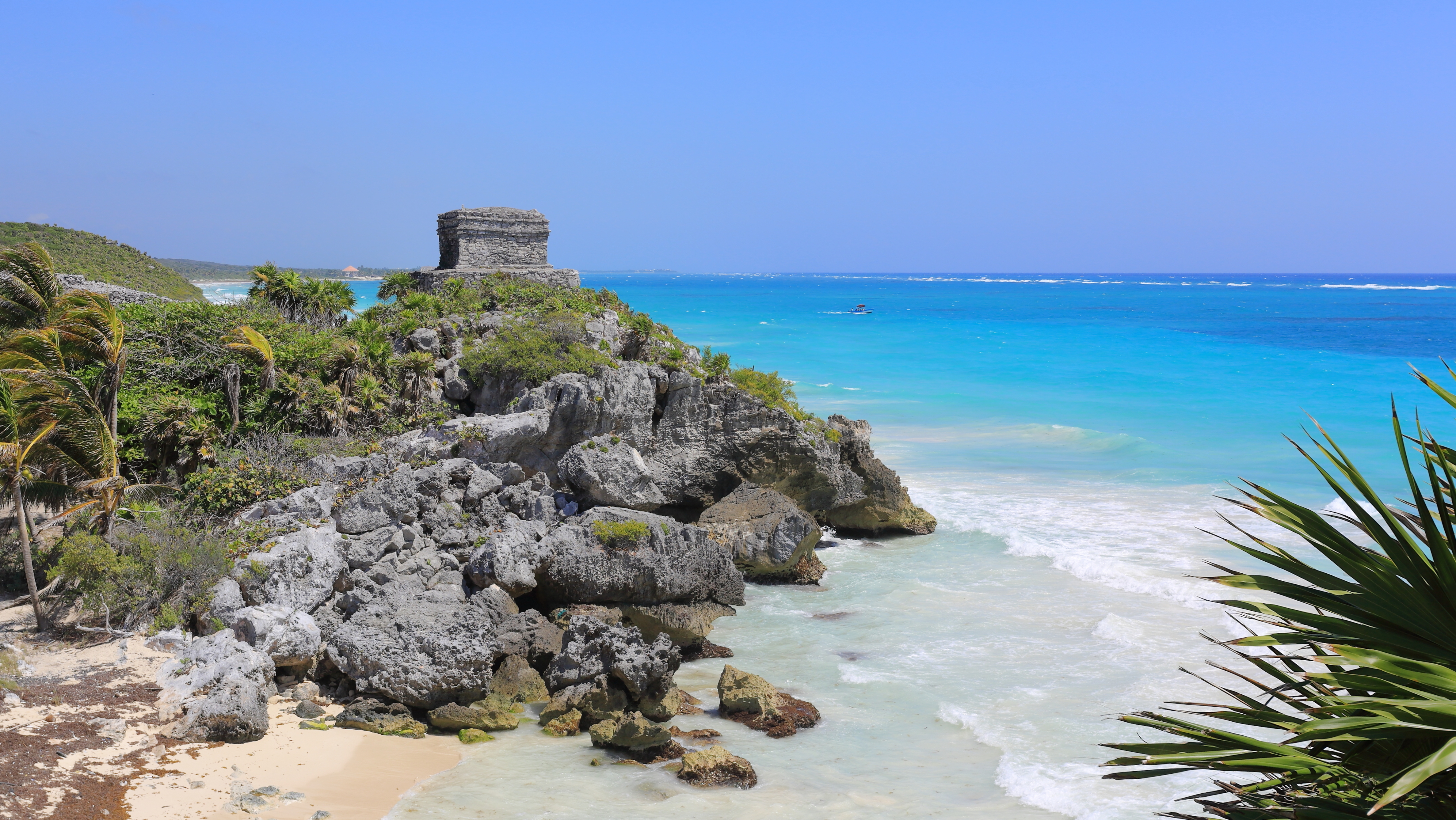
English: Tulum - God of the Winds Temple as seen from the south, March 2016
Français : Temple de Kukulcan, dieu des vents dans la religion maya, vu depuis le sud à Tulum, dans la péninsule du Yucatan, dans le sud-est du Mexique.
Polski: Widok od strony południowej na ruiny świątyni Boga Wiatrów w prekolumbijskim mieście Tulum położonym niedaleko od współczesnego miasta Tulum w meksykańskim stanie Quintana Roo.
Български: Тулум е град в Доколумбова Америка от цивилизацията на маите, служил за пристанище. Руините му се намират върху високи скали на източния бряг на полуостров Юкатан (днес в Мексико). Тулум е един от последните градове, обитавани от маите. Той достига разцвета си между 13 и 15 век и оцелява в продължение на 70 години след като испанците започват да завладяват Америка.
Čeština: Zbytky opevnění předkolumbovského mayského přístavního města Tulum na polostrově Yucatán na pobřeží Karibského moře, Mexiko. Tulum bylo jedno z posledních míst s přežívajícími Mayskými obyvateli, kteří město ovládali ještě 70 let po obsazení Mexika španělskými conquistadory.
Español: Tulum es una antigua ciudad maya de la era precolombina que sirvió como principal puerto marítimo de Cobá. Fue una de las últimas ciudades construidas y habitadas por los mayas y alcanzó su apogeo entre los siglos XIII y XV. Las ruinas de Tulum se encuentran a lo largo de acantilados con una altura de 12 metros en la costa Este de la península de Yucatán, en el actual Estado de Quintana Roo, México.
한국어: 툴룸은 콜럼버스 이전 마야 문명의 방벽으로 둘러싸인 도시로, 코바의 주요 항구였다. 유적지는 멕시코 킨타나로오 주의 카리브 해 유카탄 반도의 동해안을 따라 12 m 높이의 절벽 위에 위치한다. 툴룸은 마야가 세우고 거주한 마지막 도시들 중 하나이다. 이 도시는 13세기에서 15세기 사이 이 높이에 있었고 스페인이 멕시코를 점령하기 시작한 이후 약 70년 동안 간신히 살아남을 수 있었다.
Македонски: Рушевини на претколумбовскиот мајански утврден град Тулум — пристаниште кое го опслужувало градот Коба.
Português: Tulum, um sítio arqueológico correspondente a uma antiga cidade muralhada maia. Situa-se ao longo da costa do mar do Caribe, sudeste do México, estado de Quintana Roo, numa região conhecida como Riviera Maya. |
|||||||||||||||||
| Date | ||||||||||||||||||
| Source | Own work | |||||||||||||||||
| Author |
|
|||||||||||||||||

| Camera location | | View this and other nearby images on: OpenStreetMap |
|---|
Assessment
This image was selected as picture of the day on Wikimedia Commons for 19 July 2017. It was captioned as follows: English: Tulum is the site of a Pre-Columbian Maya walled city serving as a major port for Cobá. The ruins are situated on 12-meter (39 ft) tall cliffs, along the east coast of the Yucatán Peninsula on the Caribbean Sea in the state of Quintana Roo, Mexico. Tulum was one of the last cities built and inhabited by the Maya; it was at its height between the 13th and 15th centuries and managed to survive about 70 years after the Spanish began occupying Mexico. Other languages:
Čeština: Zbytky opevnění předkolumbovského mayského přístavního města Tulum na polostrově Yucatán na pobřeží Karibského moře, Mexiko. Tulum bylo jedno z posledních míst s přežívajícími Mayskými obyvateli, kteří město ovládali ještě 70 let po obsazení Mexika španělskými conquistadory. English: Tulum is the site of a Pre-Columbian Maya walled city serving as a major port for Cobá. The ruins are situated on 12-meter (39 ft) tall cliffs, along the east coast of the Yucatán Peninsula on the Caribbean Sea in the state of Quintana Roo, Mexico. Tulum was one of the last cities built and inhabited by the Maya; it was at its height between the 13th and 15th centuries and managed to survive about 70 years after the Spanish began occupying Mexico. Español: Tulum es una antigua ciudad maya de la era precolombina que sirvió como principal puerto marítimo de Cobá. Fue una de las últimas ciudades construidas y habitadas por los mayas y alcanzó su apogeo entre los siglos XIII y XV. Las ruinas de Tulum se encuentran a lo largo de acantilados con una altura de 12 metros en la costa Este de la península de Yucatán, en el actual Estado de Quintana Roo, México. Français : Temple de Kukulcan, dieu des vents dans la religion maya, vu depuis le sud à Tulum, dans la péninsule du Yucatan, dans le sud-est du Mexique. Polski: Ruiny świątyni Boga Wiatrów w Tulum, miejscu, w którym niegdyś znajdowało się prekolumbijskie, otoczone murem obronnym miasto służące jako główny port dla prekolumbijskiego miasta Cobá. Ruiny znajdują się na 12-metrowym klifie rozciągającym się wzdłuż wschodniego wybrzeża półwyspu Jukatan na Morzu Karaibskim, niedaleko od współczesnego miasta Tulum w meksykańskim stanie Quintana Roo. Prekolumbijskie Tulum było jednym z ostatnich miast zbudowanych i zamieszkałych przez Majów. Szczyt jego świetności przypadł na XIII–XV wiek i udało mu się przetrwać około 70 lat od momentu podbicia tych ziem przez Hiszpanów. Português: Tulum, um sítio arqueológico correspondente a uma antiga cidade muralhada maia. Situa-se ao longo da costa do mar do Caribe, sudeste do México, estado de Quintana Roo, numa região conhecida como Riviera Maya. Български: Тулум е град в Доколумбова Америка от цивилизацията на маите, служил за пристанище. Руините му се намират върху високи скали на източния бряг на полуостров Юкатан (днес в Мексико). Тулум е един от последните градове, обитавани от маите. Той достига разцвета си между 13 и 15 век и оцелява в продължение на 70 години след като испанците започват да завладяват Америка. Македонски: Рушевини на претколумбовскиот мајански утврден град Тулум — пристаниште кое го опслужувало градот Коба. |
|
This image has been assessed using the Quality image guidelines and is considered a Quality image.
|

|
This image has been assessed under the valued image criteria and is considered the most valued image on Commons within the scope: Coastal panorama with the Templo del Dios Viento, beach, and the sea, as seen from the south.. You can see its nomination here. |
Licensing
I, the copyright holder of this work, hereby publish it under the following license:
This file is licensed under the Creative Commons Attribution-Share Alike 4.0 International license.
- You are free:
- to share – to copy, distribute and transmit the work
- to remix – to adapt the work
- Under the following conditions:
- attribution – You must give appropriate credit, provide a link to the license, and indicate if changes were made. You may do so in any reasonable manner, but not in any way that suggests the licensor endorses you or your use.
- share alike – If you remix, transform, or build upon the material, you must distribute your contributions under the same or compatible license as the original.
File history
Click on a date/time to view the file as it appeared at that time.
| Date/Time | Thumbnail | Dimensions | User | Comment | |
|---|---|---|---|---|---|
| current | 15:02, 22 September 2016 | | 4,750 × 2,676 (9.2 MB) | Martin Falbisoner | repaired color profile |
File usage
The following page uses this file: