File:Shoushan National Nature Park ( WEI, WAN-CHEN ) 1.jpg
From Eco Friendly Travels

Size of this preview: 800 × 450 pixels. Other resolutions: 320 × 180 pixels | 640 × 360 pixels | 1,024 × 575 pixels | 1,600 × 899 pixels.
Original file (1,600 × 899 pixels, file size: 1.6 MB, MIME type: image/jpeg)
_1.jpg)
Summary
| Description |
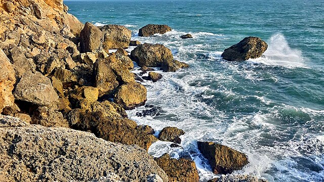
中文(臺灣):壽山位於高雄市西南方,為南北走向之珊瑚礁丘陵地,珊瑚礁岩地形發達,是高雄市的天然屏障。
English: Shoushan is located in the southwest of Kaohsiung, it is north and south toward the coral reef hilly land, coral reef rock terrain developed, is the natural barrier of Kaohsiung. |
| Date | |
| Source | Own work |
| Author | WEI, WAN-CHEN(魏琬臻) |
| Camera location | | View this and other nearby images on: OpenStreetMap |
|---|
_1.jpg¶ms=022.651111_N_0120.250278_E_globe:Earth_type:camera__&language=en)
壽山國家自然公園(Shoushan National Nature Park)
Licensing
I, the copyright holder of this work, hereby publish it under the following license:
This file is licensed under the Creative Commons Attribution-Share Alike 4.0 International license.
- You are free:
- to share – to copy, distribute and transmit the work
- to remix – to adapt the work
- Under the following conditions:
- attribution – You must give appropriate credit, provide a link to the license, and indicate if changes were made. You may do so in any reasonable manner, but not in any way that suggests the licensor endorses you or your use.
- share alike – If you remix, transform, or build upon the material, you must distribute your contributions under the same or compatible license as the original.
This image was uploaded as part of Wiki Loves Earth 2019.
|
 |
File history
Click on a date/time to view the file as it appeared at that time.
| Date/Time | Thumbnail | Dimensions | User | Comment | |
|---|---|---|---|---|---|
| current | 08:40, 3 June 2019 | | 1,600 × 899 (1.6 MB) | WEI, WAN-CHEN | User created page with UploadWizard |
File usage
The following page uses this file:
_1.jpg)