File:SJ Norge Di 4 654 Nattog 475 Trondheim - Bodø near Dalselv.jpg
From Eco Friendly Travels
Jump to:navigation, search
Size of this preview: 800 × 494 pixels. Other resolutions: 320 × 198 pixels | 640 × 395 pixels | 1,024 × 632 pixels | 1,280 × 790 pixels | 6,205 × 3,830 pixels.
Original file (6,205 × 3,830 pixels, file size: 9.21 MB, MIME type: image/jpeg)
This file is from Wikimedia Commons and may be used by other projects. The description on its file description page there is shown below.
Summary
DescriptionSJ Norge Di 4 654 Nattog 475 Trondheim - Bodø near Dalselv.jpg |
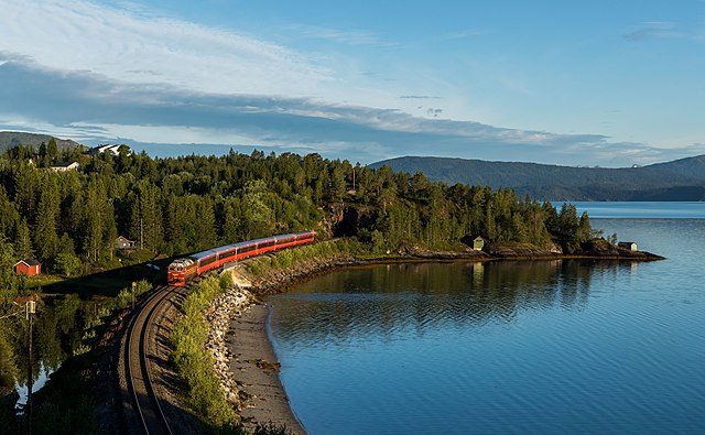
English: Di 4 654 with Nattog 475 Trondheim - Bodø a few minutes before arriving at Mo i Rana. Picture manipulation: Removed roof of a hut near the tracks at the bottom of the frame, removed some trees from the lower right corner.
Deutsch: Di 4 654 ist mit Nattog 475 Trondheim - Bodø nur noch ein paar Minuten von Mo i Rana entfernt. Bildmanipulationen: Dach eines Elektrohäuschens an den Gleisen am unteren Bildrand entfernt, einige angeschnittene Bäume in der rechten unteren Ecke entfernt. |
Date | Taken on 6 August 2020, 05:57:13 (according to Exif data) |
Source | Own work, also available at https://bahnbilder.ch/picture/37442 |
Author | Kabelleger / David Gubler |
Camera location | 66° 14′ 04.32″ N, 13° 55′ 09.67″ E | View this and other nearby images on: OpenStreetMap | 66.234533; 13.919352 |
---|
|
Licensing
I, the copyright holder of this work, hereby publish it under the following license:
This file is licensed under the Creative Commons Attribution-Share Alike 4.0 International license.
- You are free:
- to share – to copy, distribute and transmit the work
- to remix – to adapt the work
- Under the following conditions:
- attribution – You must give appropriate credit, provide a link to the license, and indicate if changes were made. You may do so in any reasonable manner, but not in any way that suggests the licensor endorses you or your use.
- share alike – If you remix, transform, or build upon the material, you must distribute your contributions under the same or compatible license as the original.
Items portrayed in this file
depicts
some value
66°14'4.319"N, 13°55'9.667"E
6 August 2020
0.001 second
7.1
57 millimetre
400
image/jpeg
File history
Click on a date/time to view the file as it appeared at that time.
Date/Time | Thumbnail | Dimensions | User | Comment | |
---|---|---|---|---|---|
current | 21:31, 11 August 2020 | 6,205 × 3,830 (9.21 MB) | Kabelleger | Uploaded own work with UploadWizard |
File usage
The following page uses this file:
Metadata
This file contains additional information, probably added from the digital camera or scanner used to create or digitize it.
If the file has been modified from its original state, some details may not fully reflect the modified file.
Camera manufacturer | Canon |
---|---|
Camera model | Canon EOS 5D Mark IV |
Author | David Gubler [email protected] |
Exposure time | 1/1,000 sec (0.001) |
F Number | f/7.1 |
ISO speed rating | 400 |
Date and time of data generation | 05:57, 6 August 2020 |
Lens focal length | 57 mm |
Latitude | 66° 14′ 4.32″ N |
Longitude | 13° 55′ 9.67″ E |
Altitude | 4.8 meters above sea level |
Orientation | Normal |
Horizontal resolution | 300 dpi |
Vertical resolution | 300 dpi |
Software used | Adobe Photoshop 21.2 (Macintosh) |
File change date and time | 23:01, 11 August 2020 |
Exposure Program | Aperture priority |
Exif version | 2.3 |
Date and time of digitizing | 05:57, 6 August 2020 |
APEX shutter speed | 9.965784 |
APEX aperture | 5.655638 |
APEX exposure bias | -0.33333333333333 |
Maximum land aperture | 3 APEX (f/2.83) |
Metering mode | Pattern |
Flash | Flash did not fire, compulsory flash suppression |
DateTime subseconds | 27 |
DateTimeOriginal subseconds | 27 |
DateTimeDigitized subseconds | 27 |
Color space | sRGB |
Focal plane X resolution | 1,866.6666564941 |
Focal plane Y resolution | 1,866.6666564941 |
Focal plane resolution unit | 3 |
Custom image processing | Normal process |
Exposure mode | Auto exposure |
White balance | Auto white balance |
Scene capture type | Standard |
GPS time (atomic clock) | 03:57 |
Satellites used for measurement | 10 |
Receiver status | Measurement in progress |
Measurement mode | 3-dimensional measurement |
Measurement precision | Poor (2.2) |
Geodetic survey data used | WGS-84 |
GPS date | 6 August 2020 |
GPS tag version | 0.0.3.2 |
Serial number of camera | 023021002584 |
Lens used | EF24-70mm f/2.8L II USM |
Rating (out of 5) | 0 |
Date metadata was last modified | 01:01, 12 August 2020 |
Unique ID of original document | 1C578C8F65357DC03FCE142EC220B050 |