File:Saint Kitts - Brimstone Hill Fortress 05.JPG
From Eco Friendly Travels

Size of this preview: 800 × 365 pixels. Other resolutions: 320 × 146 pixels | 640 × 292 pixels | 1,024 × 467 pixels | 1,280 × 584 pixels | 5,162 × 2,354 pixels.
Original file (5,162 × 2,354 pixels, file size: 8.81 MB, MIME type: image/jpeg)
Summary
| Description |
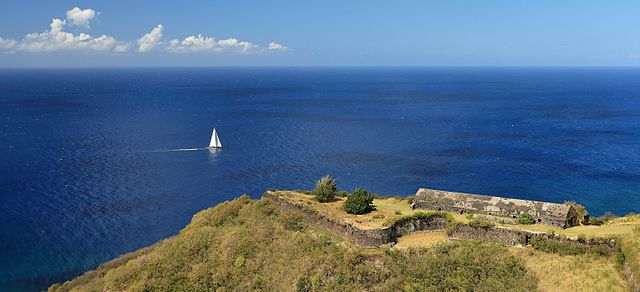
English: The Brimstone Hill Fortress on the island of St. Kitts, which was recognized World Heritage Site by the UNESCO in 1999.
Español: La Fortaleza de Brimstone Hill, que domina la costa noreste de la isla caribeña de San Cristóbal y Nieves, fue declarada Patrimonio de la Humanidad en 1999.
Polski: Twierdza na wzgórzu Brimstone dominująca nad północnym wybrzeżem karaibskiej wyspy Saint Kitts. W 1999 roku twierdzę wpisano na listę światowego dziedzictwa UNESCO.
Português: Mar do Caribe visto do Parque Nacional da Fortaleza de Brimstone Hill. Esta fortaleza, que domina a costa nordeste da ilha de São Cristóvão, em São Cristóvão e Nevis, foi declarada Patrimônio Mundial em 1999.
Українська: Карибське море та фортеця Брімстон-Гілл на острові Сент-Кіттс, яка у 1999 році була занесена до переліку Світової спадщини ЮНЕСКО
Čeština: Karibské moře viděno z pevnosti Brimstone Hill, součásti Světové dědictví UNESCO na ostrově Svatého Krištofa, stát Svatý Kryštof a Nevis.
Magyar: A Karib-tenger a Brimstone Hill Fortress Nemzeti Park felől nézve. A Kelet-karibi térségben, a Saint Kitts és Nevis Államszövetségben, a Saint Kitts-sziget egy dombján álló erőd az UNESCO világörökség része
Italiano: Il mare Caraibico visto dal Parco nazionale della fortezza di Brimstone Hill sull'isola di Saint Kitts. Il forte, progettato dagli inglesi e realizzato dagli schiavi africani nel corso del XVIII secolo, è una delle fortificazioni meglio conservate delle Americhe ed è stato registrato come patrimonio dell'umanità.
Македонски: Поглед на Карипското Море од Националниот парк Бримстоун Хил Фортрес. Тврдината се наоѓа на островот Свети Кристофер во сојузот на Свети Кристофер и Невис во источните Кариби.
Nederlands: De Caraïbische Zee gezien vanaf Brimstone Hill Fortress, een UNESCO-werelderfgoed op Saint Kitts |
|||||||||||||||||
| Date | ||||||||||||||||||
| Source | Own work | |||||||||||||||||
| Author |
|
|||||||||||||||||

| Camera location | | View this and other nearby images on: OpenStreetMap |
|---|
|
This place is a UNESCO World Heritage Site, listed as
Brimstone Hill Fortress National Park.
|
Assessment
|

This image was selected as picture of the day on Wikimedia Commons for 13 February 2017. It was captioned as follows: English: The Caribbean Sea as seen from Brimstone Hill Fortress National Park. This fort is a UNESCO World Heritage Site, a well-preserved fortress on a hill on the island of St. Kitts in the Federation of St. Christopher (St. Kitts) and Nevis in the Eastern Caribbean. Other languages:
Čeština: Karibské moře viděno z pevnosti Brimstone Hill, součásti Světové dědictví UNESCO na ostrově Svatého Krištofa, stát Svatý Kryštof a Nevis. English: The Caribbean Sea as seen from Brimstone Hill Fortress National Park. This fort is a UNESCO World Heritage Site, a well-preserved fortress on a hill on the island of St. Kitts in the Federation of St. Christopher (St. Kitts) and Nevis in the Eastern Caribbean. Español: La Fortaleza de Brimstone Hill, que domina la costa noreste de la isla caribeña de San Cristóbal y Nieves, fue declarada Patrimonio de la Humanidad en 1999. Italiano: Il mare Caraibico visto dal Parco nazionale della fortezza di Brimstone Hill sull'isola di Saint Kitts. Il forte, progettato dagli inglesi e realizzato dagli schiavi africani nel corso del XVIII secolo, è una delle fortificazioni meglio conservate delle Americhe ed è stato registrato come patrimonio dell'umanità. Magyar: A Karib-tenger a Brimstone Hill Fortress Nemzeti Park felől nézve. A Kelet-karibi térségben, a Saint Kitts és Nevis Államszövetségben, a Saint Kitts-sziget egy dombján álló erőd az UNESCO világörökség része Nederlands: De Caraïbische Zee gezien vanaf Brimstone Hill Fortress, een UNESCO-werelderfgoed op Saint Kitts Polski: Widok na Morze Karaibskie z wpisanej na listę światowego dziedzictwa UNESCO twierdzy na wzgórzu Brimstone na wyspie Saint Kitts należacej do państwa Saint Kitts i Nevis. Português: Mar do Caribe visto do Parque Nacional da Fortaleza de Brimstone Hill. Esta fortaleza, que domina a costa nordeste da ilha de São Cristóvão, em São Cristóvão e Nevis, foi declarada Patrimônio Mundial em 1999. Македонски: Поглед на Карипското Море од Националниот парк Бримстоун Хил Фортрес. Тврдината се наоѓа на островот Свети Кристофер во сојузот на Свети Кристофер и Невис во источните Кариби. |
Licensing
I, the copyright holder of this work, hereby publish it under the following license:
This file is licensed under the Creative Commons Attribution-Share Alike 4.0 International license.
- You are free:
- to share – to copy, distribute and transmit the work
- to remix – to adapt the work
- Under the following conditions:
- attribution – You must give appropriate credit, provide a link to the license, and indicate if changes were made. You may do so in any reasonable manner, but not in any way that suggests the licensor endorses you or your use.
- share alike – If you remix, transform, or build upon the material, you must distribute your contributions under the same or compatible license as the original.
File history
Click on a date/time to view the file as it appeared at that time.
| Date/Time | Thumbnail | Dimensions | User | Comment | |
|---|---|---|---|---|---|
| current | 14:53, 22 September 2016 | | 5,162 × 2,354 (8.81 MB) | Martin Falbisoner | repaired color profile |
File usage
The following page uses this file: